Correcting Motion Distortion for LIDAR Scan-to-Map Registration
https://github.com/mcdermatt/VICET
Because scanning-LIDAR sensors require finite time to create a point cloud, sensor motion during a scan warps the resulting image, a phenomenon known as motion distortion or rolling shutter.Motion-distortion correction methods exist, but they rely on external measurements or Bayesian filtering over multiple LIDAR scans. In this letter we propose a novel algorithm that performs snapshot processing to obtain a motion-distortion correction. Snapshot processing, which registers a current LIDAR scan to a reference image without using external sensors or Bayesian filtering, is particularly relevant for localization to a high-definition (HD) map. Our approach, which we call Velocity-corrected Iterative Compact Ellipsoidal Transformation (VICET), extends the well-known Normal Distributions Transform (NDT) algorithm to solve jointly for both a 6 Degree-of-Freedom (DOF) rigid transform between a scan and a map and a set of 6DOF motion states that describe distortion within the current LIDAR scan. Using experiments, we show that VICET achieves significantly higher accuracy than NDT or Iterative Closest Point (ICP) algorithms when localizing a distorted raw LIDAR scan against an undistorted HD Map
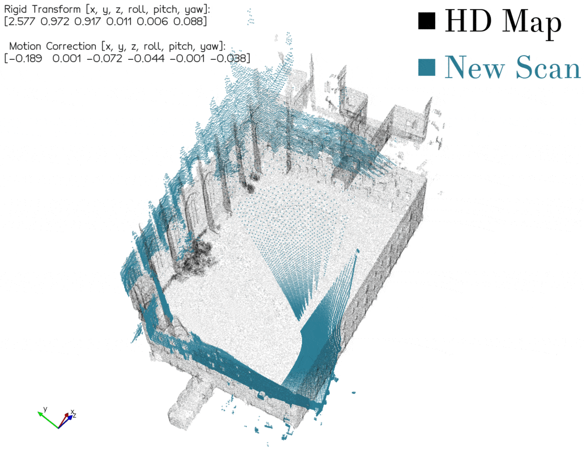
VICET is capable of jointly estimating both the rigid transform and the relative motion correction required to fit a distorted scan to a reference point cloud. The "Rigid Transform" states represent the difference in pose between the origin of the keyframe scan and the origin of the new scan. The "Motion Correction" states estimated by VICET represent the apparent differences in the motion of the sensor during the recording of the second scan relative to the first. Correctly estimating these 12 parameters allows a distorted scan to be rectified to properly align with a keyframe scan.
VICET is particularly useful in the task of registering a raw distorted point cloud to an undistorted HD Map.
Motion of the sensor during the period of a LIDAR scan will stretch the resulting point cloud. Rigid scan registration techniques fail to account for this stretching and as a result will produce biased localization estimates. Strategies exist to account for motion distortion in point clouds, however they rely on either external sensor information or a sequence of multiple LIDAR scans to account for distortion. VICET is unique in that it can solve for both the rigid trnansform and motion distortion states required to properly align a distorted point cloud with a reference scan. As we demonstrate in our paper, this allows VICET to achieve signficantly higher localization accuracy than rigid point cloud registration methods like NDT or ICP.